
Comment on the Proposed Placetypes here...
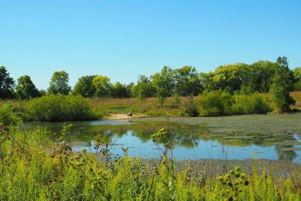
Natural Areas and Open Space
Naturals areas and open spaces include sensitive environmental features like waterways, forests, wetlands, floodplains, parks, and wildlife corridors. These areas should have minimal to no human disturbance. Conservation and restoration are important aspects of this placetype, especially to encourage efforts to improve biodiversity and manage the natural flow of floods to boost the land’s ability to reduce natural disaster impacts and the City’s ability to recover from them.
Defining Features
- Water resources, especially wetlands and aquifers that naturally filter and cleans groundwater, are conserved.
- Green spaces are accessible by people of all ages and abilities, providing a quiet reprieve from the busy city and a place to reflect and experience nature.
- Forests, prairies, and other natural areas are or should become interconnected, creating wildlife corridors that help to restore nature by having minimal to no disturbance from humans.
- In some areas, such as Brandywine Creek, recreational assets like parks, trails, and facilities for education about nature are encouraged to improve residents’ quality of life and connection to nature.
- Dedicated spaces for public gatherings, events, and art are encouraged, given their is minimal impact to the environment, to promote social connection, community pride, and a sense of belonging.
- Pedestrians and bicyclists take priority as the main forms of transportation. This can be accomplished by a highly connected trail network between built-up and natural areas.
- Car parking is strategically placing vehicular parking at key points of interest where vehicular access is necessary or highly desirable.


Rural Reserve
The Rural Reserve is characterized by a mix of agricultural uses with single-family residences scattered along county roads and generally fewer utilities and services, which help discourage more intensive and large-scale developments. Programs such as farm-to-table, farmers’ markets, and community supported agriculture (CSA) are highly encouraged. Development is discouraged where it would restrict or prevent the future extension of water, sewer, and roadway improvements for the buildout of these areas. Any new buildings should be designed around natural features to protect forested areas, farm viewsheds, water resources, and tree rows. Since urban and suburban style development is discouraged, the City, at this time, should not seek to incorporate land in the placetype, and instead work with Hancock County in a joint effort to preserve the area. As conditions change in the area, the City may want to change its policy in future updates to the Plan.
Defining Features
- Open sky and county roads lined with crops, interspersed with single-family homes, define the landscape.
- Viewsheds across acres of farmland and open space create a rural atmosphere and provide a reprieve from city life.
- Agricultural uses are sufficiently buffered from waterways, forming riparian buffers that provide wildlife habitat, improve water quality, and reduce soil erosion.
- Farm vehicles and equipment are frequent users of the street network and are accommodated with wider medians on either side of the street.
- There are opportunities for agricultural tourism, such roadside produce stands and farm tours, that encourage relationships between rural and urban areas.
- Sidewalks and trails are sparse but connect to significant greenspaces and natural features.


Estate Neighborhood
This placetype emphasizes low-intensity development designed around natural features in the land, including but not limited to topography, forested areas, and water resources. It should serve as a well-planned transitional step from urban to rural parts of the Planning Area. Most developments should feature large-lot single-family subdivisions, accessory dwelling units, parks and common areas to maintain open space and natural features. The construction of these developments should also have low impacts on the land, such as limited or no use of clear cutting, top-soil stripping, leveling vast areas, and other practices that lead to degraded land and soil health.
Defining Features
- Development is limited to detached single-family homes and accessory dwelling units (ADUs) to preserve the area’s rural and spacious character while maintaining a low-density residential focus.
- Parks, greenways, and trails provide outdoor recreational opportunities while protecting the area’s natural beauty and environmental integrity.
- Strict growth standards and the limited placetype boundary ensure controlled development to prevent urban sprawl and support low-impact development.
- Abundant open spaces create a peaceful, secluded environment for residents seeking privacy and tranquility.


Key Concept: Conventional to Conservation Subdivision Design
Same number of homes, but natural features, open space, and/or farmland are better or permanently preserved in one large, undivided parcel (sometimes known as ‘common area’).


Suburban Neighborhood
This placetype is primarily a residential area intended for detached, single-family homes and small-scale multi-family homes that create a quiet neighborhood atmosphere and privacy between properties. Homes typically have larger backyards than front yards, creating a more pedestrian-friendly environment and fostering opportunities for socializing with neighbors on front porches. Sidewalks, trails, and bike paths link neighborhoods to parks and stores to encourage healthier lifestyles and enhance safety, particularly for children and those without vehicle access. To support people’s daily needs while maintaining majority residential buildings, small-scale corner stores, senior care, and daycares may conditionally be located at key intersections.
Defining Features
- Low-density, detached single-family homes with some moderate density housing options (e.g., duplexes) are integrated thoughtfully to maintain the neighborhood character.
- A network of sidewalks, trails, and greenways promote walkability within and between neighborhoods, parks, and community amenities, ensuring accessibility and safety.
- Plenty of parks, open spaces, native plantings, and tree-lined streets provide opportunities for outdoor recreation, relaxation, and community gatherings while supporting biodiversity and stormwater management, contributing to a high quality of life.
- Strategically located small-scale commercial uses, such as corner stores or specialty grocery stores, may be present to cater to residents’ daily needs.
- The quiet, private residential atmosphere is complemented by well-maintained gathering spaces and facilities that foster a sense of belonging and pride.


Mixed Residential Neighborhood
A variety of housing types, interspersed with well-placed greenspaces, trails, corner stores, and other gathering spaces characterize Mixed Residential Neighborhoods. Most developments should be relatively more compact, such as placing buildings closer together, closer to the street, and having alley access. However, the ‘mixed’ nature of the placetype allows both driveways and alleys to be present in a neighborhood. Denser home types, such as townhomes, should be located closer to commercial uses, gradually transitioning out to lower density homes. The mix of housing choices combined with corner shops and trails makes biking and walking safe and convenient options to accomplish daily necessities.
Defining Features
- A mix of housing types, from single-family detached homes to multi-family developments, accommodate various needs and ensure compatibility with surrounding development.
- Community-oriented and essential services like schools, parks, places of worship, and senior care facilities foster a sense of community and improve residents’ quality of life.
- Small-scale businesses, such as grocery stores, restaurants, and personal services, are strategically located along major intersections and key corridors to provide residents with daily necessities while preserving the area’s residential character.
- Artisanal workshops, agricultural tourism, and recreational and entertainment uses diversify land use and strengthen the local economy, provided they remain compatible with the surrounding area.
- Safe and well-designed bicycle and pedestrian infrastructure connects homes to commercial nodes, institutional uses, and surrounding placetypes. Features like high-visibility crossing and signalized intersections encourage active transportation.
- Environmentally conscious practices, such as water-efficient landscaping, native plantings, and sustainable stormwater management systems, strengthen environmental resilience while reducing infrastructure demands.


Neighborhood Center
The Neighborhood Center serves as a vibrant commercial and civic hub for community activities, offering a mix of residential, commercial, and institutional uses in a compact and walkable setting. It is typically located at key intersections and provides convenient access to goods, services, and gathering spaces for nearby neighborhoods. Pedestrian and cycling infrastructure enhance connectivity to the rest of the community, especially downtown Greenfield, through wayfinding signage and safe streets.
Defining Features
- Mixed-use hubs that integrate residential, commercial, and civic uses in a compact, walkable environment.
- A variety of housing types are integrated into the neighborhood.
- Essential businesses like grocery stores, restaurants, retail shops, and professional offices are strategically placed to meet the daily needs of residents and support economic vitality
- Civic and institutional uses, including parks, childcare services, and senior care facilities, contribute to the neighborhood’s social and cultural fabric. These spaces foster a sense of belonging, encourage gathering, and support recreational opportunities.
- Comprehensive cycling and pedestrian infrastructure ensure safe and efficient connections between homes, businesses, and civic spaces.
- Public space features, such as wide sidewalks, shaded seating, and bicycle racks, encourage active transportation and reduce dependency on cars within the placetype.
- Higher-density development with a human-scale environment. Buildings typically feature active ground floor uses with upper-story residences or offices, ensuring efficient land use while preserving a community-focused atmosphere.


Core Neighborhood
The Core Neighborhood features a diverse mix of housing types, ranging from historic single-family homes and townhomes to low-rise apartment buildings like small courtyard buildings. Many of these structures date back several decades, reflecting architectural styles from various eras. Housing density tends to be higher than in suburban areas, with residences often built closer together and closer to the street. This variety in housing accommodates a range of lifestyles and residents, including long-time homeowners, renters, and newcomers drawn to the community’s more urban character.
Defining Features
- Developments are alley-loaded.
- Buildings reflect a range of architectural styles from different eras.
- Traditional street grid with great connections downtown.
- Mix of housing options and opportunities for infill development such as accessory dwelling units.
- Buildings are built close to the street and to each other, with front porches to promote spontaneous social interactions.
- Intersections are “daylighted,” narrower lanes to slow down vehicles, and discouraging through-traffic to improve safety for pedestrians and bicyclists.
- Corner stores and services like childcare along major throughfares and select intersections.


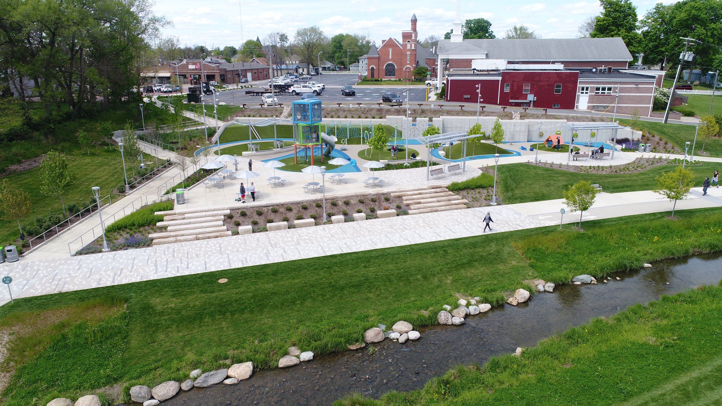
Downtown Mixed-Use
The Downtown Mixed-Use area celebrates Greenfield’s heritage through architecture, attractive locally owned businesses, and year-round events that reflect its unique culture and history. With plenty of open-air seating, street art, artisanal workshops, Downtown Greenfield buzzes with an atmosphere of excitement and opportunity. Streets are lined with well-preserved historic buildings and murals that pay homage to the town’s roots, while new developments blend seamlessly, honoring the legacy while embracing opportunities for new spaces and experiences. With a renewed emphasis on walkability and economic vibrancy, the downtown serves as a living testament to the past and a foundation for future generations.
Defining Features
- Represents the heart of the city, where public spaces and plazas are used for events activities that bring the community together.
- There are boundless economic opportunities for small and local businesses with spaces for start-ups and innovative practices are tested.
- The historical street grid remains intact, and gaps are filled in to enhance connections with adjacent residential neighborhoods.
- Pennsy Trail and US 40 forms the backbones of downtown, with connected mixed-use developments, greenspaces, and gathering and event spaces.
- Commercial and mixed-use buildings, with residences and/or offices above retail and restaurants, follow the traditional development style of wall-to-wall buildings.
- Wide sidewalks with space for outdoor dining/seating, public art, decorative streetlights, trees, and benches for rest.


Suburban Commercial Center
Suburban Commercial Centers are located at major intersections and along key corridors, serving multiple surrounding neighborhoods and attracting retailers and services that require a larger market area. A mix of commercial, office, residential, retail, and services are concentrated adjacent to larger nodes of activity. Commercial centers, major corridors, and office parks are prime locations for this placetype. Nearby patrons can comfortably walk or bike to the center, while faraway patrons can easily find parking with clear signage. While shopping, people can stroll through tree-lined sidewalks and spaces filled with locally made art that give the area a unique charm.
Defining Features
- Storefronts are oriented toward shared spaces, such as plazas or greenspaces, which integrate areas for social gatherings, rest, play, dining, and general leisure.
- Vacant properties and underused parking areas provide opportunities for redevelopment for mixed-use and residential structures providing housing and housing choice in and around our neighborhoods.
- Buildings are designed with attractive architecture, and adaptable spaces that can be reused for a variety of purposes to sustain the long-term value and viability of commercial areas.
- Discourage direct connections to major roads to reduce disruptions to traffic flow and improve pedestrian/bicyclist safety by limiting traffic turning from major roads to key intersections
- Buildings are integrated with each other and into trail networks with the rest of the community for convenient, safe, and accessible ways to walk or bike.
- A variety of housing choices are incorporated into mixed-use buildings to diversify the housing stock, including more options for homeownership like condos.


Employment Hub
Employment Hubs are intended for regional-scale employment and industry. This placetype should be near interstates or major roads that can accommodate large volumes of traffic, including cars, trucks, bikes, and buses. Each hub is enriched by partnerships with nearby schools and universities, not-for-profits, and training centers, providing lifelong educational opportunities, upskilling programs tailored to local and regional industries, and research labs and offices. With a focus on innovation and collaboration, Employment Hubs should foster a thriving labor market and business environment.
Defining Features
- Cluster buildings together around shared greenspaces and connect them with pedestrian pathways to create campus-style research and manufacturing centers.
- Development is encouraged near areas with easy access to major transportation routes such as interstates and where truck traffic can be diverted from local roads and areas with Neighborhood Centers.
- Transportation to and from Employment Hubs should commuters efficiently, effectively, and safely no matter what transportation option with which they can or choose to use.
- Attractive architecture, multipurpose, and adaptive spaces are built-in to developments to sustain the long-term value and viability of buildings.
- Service bays, parking areas, and other back-of-building functions located behind buildings and screened with vegetation, tree lines, and small hills.
- Streets are well-designed to separate truck traffic from other road users as much as possible.
- Use renewable energy like rooftop solar panels and incorporate green infrastructure into buildings to reduce negative environmental impacts.
- Identify opportunities to reduce and reuse potable water resources.


Connecting Districts
Connecting Districts
Unlike other placetypes, Connecting Districts are meant to modify the characteristics of placetypes along specific and significant streets in the Planning Area, shown as blue lines on the Future Development Map. Mixed-use developments that activate the streetscape, such as outdoor seating, plazas, wider trails, and bike parking are highly encouraged. Commercial and employment activities, such as restaurants, retail, offices, and light industrial are the primary uses. Multifamily residential and institutional uses are secondary uses and allow for the development of mixed-use projects. Like all placetypes, new developments should respect the character of already established developments nearby. Learn more here: http://designyourtown.org/strategy/orient-building.


Special Areas
On the other hand, “Special Areas” are parts of the community that have unique or ‘special’ conditions such as topography, a significant location, and/or serve an important function for the greater community. Typically, this includes schools, healthcare, transportation hubs, and other large-scale public amenities. These special areas include:
- Amplify Hancock
- Greenfield Central Junior High
- Greenfield Central High School
- Harris Elementary
- JB Stephens Elementary School
- Hancock County Law Enforcement
- Hancock County Fairgrounds
- Hancock Regional Hospital
- Hancock County Highway Department
- Park Cemetery/Sewer Treatment Plant
- Interstate-70 Rest Stop
- Mixed-Use Lifestyle Center (see Opportunity Parkway/State Road 9 Design Concept)
Gateways and New Parks
Gateways
Like Connecting Districts, Gateways represent a special development consideration rather than a defined area on the Future Development Map. Gateways are located at significant entry points into the Planning Area and should be used to create a sense of arrival for visitors to and residents of Greenfield. This sense of arrival can be created through signs, monuments, or archways designed in a way that represents the community’s heritage, history, and culture. Creativity is encouraged when deciding how best to site and design gateways.
New Parks
Similar to Connecting Districts and Gateways, the map symbol for “New Parks” represent a special development consideration rather than a defined area. There are several areas defined in the Future Development Map where City staff and officials should consider a new park to ensure families and residents in new developments remain well-served and have opportunities to connect with nature. The purpose, design, and amenities of these parks should follow guidelines established in the City’s Parks and Recreational Master Plan, as well as provide opportunities for public input.


